
Kayenta, Arizona: A Gateway to the Navajo Nation

Katelyn A. Claw
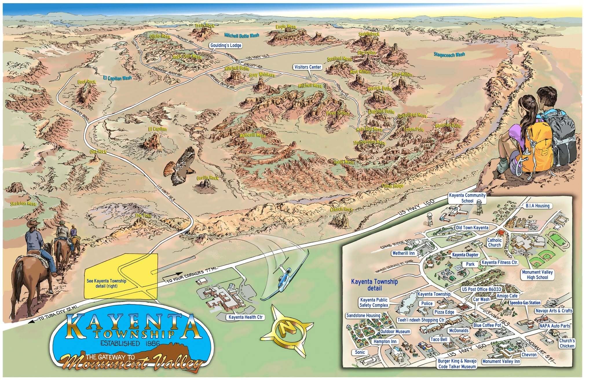
Travelers passing through northern Arizona will find that Kayenta is more than a stop for fuel or food. Located on the Navajo Nation, Kayenta provides access to some of the Southwest’s best-known parks, monuments, scenic drives, and cultural destinations.
Visitors can stay overnight, enjoy local food, shop for authentic Navajo arts and crafts, and use Kayenta as a starting point for several day trips. The community sits near the junction of U.S. Highway 160 and U.S. Highway 163, making it a practical stopping point for travel through Arizona, Utah, Colorado, and New Mexico.
What Visitors Can Find in Kayenta
While in Kayenta, travelers can:
- Stay at local hotels and lodging properties.
- Eat at local restaurants and familiar roadside stops.
- Purchase fuel, groceries, travel supplies, and vehicle services.
- Shop for Navajo jewelry, pottery, rugs, artwork, and other handmade items.
- Learn about Navajo history, including the service of the Navajo Code Talkers.
- Meet local tour operators who provide guided trips in Monument Valley and other approved visitor areas.
- Rest before continuing toward Page, the Grand Canyon, Mesa Verde, Canyon de Chelly, or the Four Corners region.
Buying directly from local artists, guides, restaurants, and businesses keeps more visitor spending within Navajo communities.
Destinations Near Kayenta
Drive times and distances are estimates from central Kayenta. Weather, construction, road conditions, and seasonal traffic may affect travel.
Monument Valley Navajo Tribal Park
Approximately 25 miles north, or about 30 minutes
Monument Valley is one of the most recognized landscapes in the Southwest. Visitors can see sandstone formations from the visitor center or travel the scenic loop when conditions permit. Navajo-guided vehicle, horseback, and photography tours are also available.
Monument Valley is a Navajo Tribal Park, not a National Park Service property. Admission fees and operating hours apply. Review current information from Navajo Nation Parks and Recreation before traveling.
Navajo National Monument
Approximately 30 miles west, or about 40 minutes
Navajo National Monument protects Betatakin, Keet Seel, and Inscription House, three ancestral Pueblo cliff dwelling sites. The park offers a visitor center, self-guided trails, seasonal ranger programs, and camping.
The park is open year-round and does not charge an entrance fee. Guided hikes may be seasonal or limited. Check the Navajo National Monument visitor information before leaving Kayenta.
Goosenecks State Park
Approximately 50 miles north, or about one hour
Goosenecks State Park overlooks deep bends in the San Juan River. It is a good roadside destination for sightseeing and photography. Services are limited, so visitors should carry water, fuel, and other supplies.
Four Corners Monument
Approximately 80 miles east, or about 90 minutes
Four Corners Monument marks the meeting point of Arizona, New Mexico, Colorado, and Utah. The site is managed by Navajo Nation Parks and Recreation. Visitors can also purchase food and handmade work from local vendors when available.
Natural Bridges National Monument
Approximately 100 miles north, or about two hours
Natural Bridges National Monument in southern Utah features three large natural bridges. Visitors can follow a scenic road, stop at overlooks, and choose from several hiking trails. Some routes between Kayenta and the monument pass through remote areas with limited services.
Canyon de Chelly National Monument
Approximately 100 miles southeast, or about two hours
Canyon de Chelly is jointly connected to the National Park Service and the Navajo Nation. Diné families continue to live, farm, and raise livestock within the canyon.
Visitors can drive the paved North and South Rim roads and stop at public overlooks. Travel into restricted canyon areas generally requires an authorized Navajo guide. Current maps and visitor information are available from Canyon de Chelly National Monument.
Glen Canyon National Recreation Area and Lake Powell
Approximately 100 miles west, or about two hours
The Page area provides access to Glen Canyon Dam, Lake Powell, Horseshoe Bend, boating areas, trails, and scenic overlooks. Conditions and access can change based on weather, water levels, and construction.
Visitors should review the Glen Canyon National Recreation Area travel information before traveling.
Grand Canyon National Park, Desert View
Approximately 125 miles southwest, or about two hours and 15 minutes
The East Entrance at Desert View is the closest Grand Canyon entrance to Kayenta. Desert View provides access to canyon overlooks and the scenic road leading toward Grand Canyon Village.
The South Rim is open throughout the year, but weather can affect roads and services. Entrance fees apply. Visit the Grand Canyon National Park planning page for current conditions.
Mesa Verde National Park
Approximately 145 miles northeast, or about three hours
Mesa Verde National Park in Colorado protects ancestral Pueblo sites, including cliff dwellings and mesa-top communities. Some cliff dwelling tours require advance reservations, and reaching park sites can take more than an hour after entering the park.
Review tour schedules, road conditions, and reservations through Mesa Verde National Park.
Petrified Forest National Park
Approximately 160 miles south, or about three hours
Petrified Forest National Park features petrified wood, desert overlooks, historic Route 66 sites, trails, and the Painted Desert. It can be included as part of a longer trip toward Holbrook, Winslow, or Interstate 40.
Travel Respectfully on the Navajo Nation
The Navajo Nation is home to families, livestock operations, businesses, cultural sites, and areas that are not open to the public. Visitors should:
- Remain on public roads and marked visitor routes.
- Do not enter homes, grazing areas, private property, or restricted sites.
- Ask before photographing people, homes, ceremonies, livestock, or artwork.
- Follow all posted photography and drone restrictions.
- Purchase tours from authorized guides.
- Carry water and keep the fuel tank filled.
- Do not rely only on cellular service or GPS in remote areas.
- Check weather and road conditions before leaving the highway.
- Pack out trash and leave cultural items where they are found.
- Remember that the Navajo Nation observes daylight saving time, while most of Arizona does not.
Make Kayenta Part of the Trip
Kayenta gives travelers a place to rest, eat, shop, and prepare for the next part of their journey. It also offers a starting point for exploring Navajo Nation destinations and nearby National Park Service sites.
Instead of driving straight through, visitors are encouraged to spend time in the community, support local businesses, meet Navajo artists and guides, and learn more about the people and places of the region.
Before traveling, confirm current hours, fees, permits, tours, and road conditions through the Navajo Nation Tourism Department, Navajo Nation Parks and Recreation, or the National Park Service.